
Continuous Cover
Management occurs at a pasture and allotment scale. Often assessments of pastures and allotments are conducted using small and infrequent ground-based plots. These plots are not representative of large geographic areas. Alternatively, pastures and allotments are assessed using 30 meter national level remote sensing products. These products are generally too coarse in detail to make management level decisions. ORC has developed 1 meter resolution remote sensing products that provide the detail needed to make management decisions.

Our Continuous cover mapping results in every 1 meter square across the landscape having a percent cover value of Plant functional groups including but not limited to, bare ground, litter, shrub, perennial and annual grass. This interpolative mapping technique far surpasses historic mapping techniques and creates a precise, fine scale map that gives the land manager a clear representation and quantification of what the vegetation conditions are at any given 1 meter pixel. Currently, national 30m mapping for applications such as these do not provide enough detail at the allotment and pasture level, therefore not meeting the needs of the managers attempting to use them.
These maps identify critical sage-grouse habitat, extreme fire danger, sagebrush cover estimates, bare ground percentage (linked to soil health and productivity) and overall rangeland health.
ORC’s ability to assess rudimentary ground cover conditions over an entire landscape robustly describes and area’s functionality and can detect trends. This allows for the analysis of the relationship between management action (e.g., grazing and land treatments) and conditions.
Drone Footage of a Corral with varying amounts of sagebrush
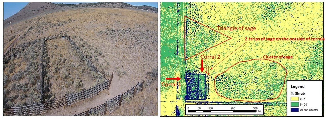
Comparing ORC's sagebrush map to real life photo
Real Picture comparison to the actual amount of sagebrush and how ORC maps sagebrush notice that:
Corral 1 has thicker sagebrush (mapped dark blue)
Corral 2 is lighter sagebrush (shown in green)
Sagebrush triangle beyond the corrals (showing in green)
2 strips of sagebrush along the corral (mapped in blue)
Sagebrush cluster to the right of the corrals (mapped green and blue)